Snippets of Information
Geographical features (Physiographic Divisions) - Rivers of India
* 18 Jul 2026
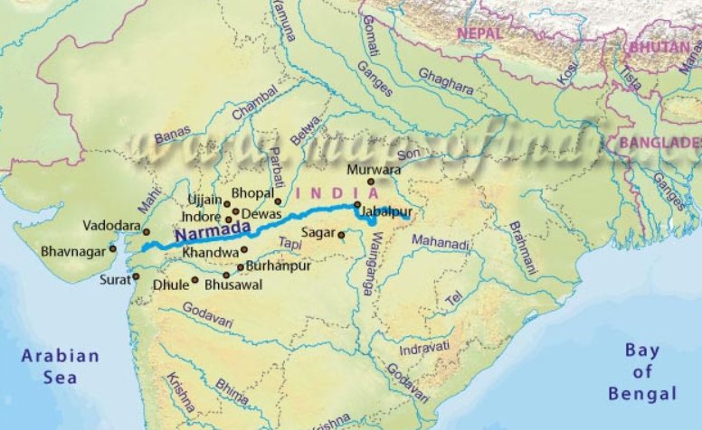
Image Source: mapsofindia.com
Being the 5th largest state in India, Gujarat is home to over 185 rivers, and one of them is the Narmada River. It flows from east to west and empties into the Arabian Sea.
Narmada is the largest river of Gujarat and the 5th largest river
in India and is also known by other names such as Rewa, Amarja,
Mekalkanya, Rudrakanya. 'Narma' means happiness or joy and 'Da' means
giver.
It originates from a spring in the flat plains of Amarkantak in
the Maikal Hills of Madhya Pradesh at an altitude of approximately 1,057
meters above sea level. Unlike the mighty Himalayan rivers that rush
down with tremendous force, the Narmada is calm and serene for most of
its length. The Narmada River begins its gentle journey from a small
pond called Narmada Kund, situated in Amarkantak town in Madhya Pradesh.
Called the "Ganga of Madhya Pradesh", it starts flowing westward
between the Vindhya and Satpura ranges for about 1,312 kilometres,
passes through green valleys and forests of Madhya Pradesh, entering
into a small part of Maharashtra and then finally travels through
Gujarat and peacefully merges within the Arabian sea in the Gulf of
Khambhat.
The Narmada River is fed by 41 significant tributaries that bring water
from its vast catchment area. The main tributaries joining from the left
include the Burhner, Banjar, Sher, Shakkar, Dudhi, Tawa, Ganjal, Chhota
Tawa, Kundi, Goi, and Karjan. Those joining from the right are the
Hiran, Gaur, Barna, Tindoni, Kolar, Chankeshwar, Kanar, Man, Uri, and
Orsang.
The total basin area of the Narmada River is 97,410 square kilometres.
Of this, the largest share – 85,858 sq. km lies in Madhya Pradesh, while
9,894 sq. km falls in Gujarat and 1,658 sq. km in Maharashtra. The
drainage area up to dam site covers around 88,000 square kilometres. The
basin receives an average annual rainfall of 112 centimetres. The
Vindhya range in the North, the
Satpura range in the South, the Maikala range in the East and the
Arabian Sea in the West forms the boundaries of the basin.
Source: ssnnl.gujarat.gov.in
The Narmada is different from most major Indian rivers. While they flow
east to the Bay of Bengal, the Narmada flows west. This is due to the
natural rift valley shape of the land.
The Sardar Sarovar Dam: This dam has been built on the Narmada River in
Gujarat and is considered among the largest dams in the world. It
supplies drinking water to many villages and cities, irrigates large
areas of barren lands (especially in the dry zones of Kutch and
Saurashtra) and produces huge amounts of electricity through hydropower
plants.
The Statue of Unity: The Statue of Unity stands on an island amidst the
river, facing the Sardar Sarovar Dam. This statue is dedicated to the
freedom fighter Sardar Vallabhbhai Patel and is the tallest statue in
the world (182 m).
Source: Longest River in Gujarat: This 1,312 km Gujarat’s Lifeline Divides North From South India by Kriti Barua, jagranjosh.com
* 18 Jul 2026
Rajasthan is the 12th state of India and the 2nd largest state by area. The state is home to 40 rivers, one of which is the Banas River.
It is the largest river in Rajasthan that flows entirely in the state.
The Banas River, also known as 'Van ki Asha' (which translates to "Hope
of the Forest"). It acts as a primary lifeline for drinking water and
agricultural irrigation across multiple districts.
The Banas River originates from the Khamnor Hills, which are a part of
the Aravalli Mountain range, near the town of Kumbhalgarh in Rajsamand,
Rajasthan. The total length of the Banas River is approximately 512 km
(318 miles). The river flows through the cities of Nathdwara, Tonk,
Jahazpur, Chaksu and the districts of Rajsamand (point where it
originates), Udaipur, Chittorgarh, Bhilwara, Ajmer, Tonk, Sawai
Madhopur. It flows in a northeasterly direction across the plains of
Rajasthan until it merges as a major tributary into the Chambal River at
a holy confluence called Rameshwar Ghat in the Sawai Madhopur district.
The Chambal River is the longest river in Rajasthan. On the other hand,
the Banas River is the longest river in Rajasthan, flowing entirely in
the state.
Source: Meet Banas River: Rajasthan's 512-km-long river that vanishes and comes back to life by Kriti Barua, jagranjosh.com
* 18 Jul 2026
The Chambal River, the longest in Rajastan, starts from the
Janapav Hills in the Vindhya Range near Mhow, Madhya Pradesh. It passes
into Rajasthan at Chaurasigarh in the Chittorgarh district and flows in a
northeast direction, covering the Kota, Bundi, Sawai Madhopur, Karauli,
and Dholpur districts and terminates by joining the Yamuna River in
Etawah, Uttar Pradesh. The length of the river is about 1,024 km, of
which 322 km flows in Rajasthan.
Source: Meet Banas River: Rajasthan's 512-km-long river that vanishes and comes back to life by Kriti Barua, jagranjosh.com
* 27 Feb 2026
The Ghaggar River is an intermittent river that flows in India and Pakistan only during the monsoon season.
It rises from the Shivalik Range of northwestern Himachal Pradesh. After
passing through the Ambala and Hissar districts of Haryana, it
disappears into the Thar Desert in Rajasthan. This seasonal river feeds
two irrigation canals that extend into Rajasthan.
Several historians identify Ghaggar with the Vedic Saraswati River.
Along the banks of the Ghaggar River, many settlements of the Indus
Valley Civilization have been excavated. It is believed that the rivers
Sutlej and Yamuna once flowed into the Ghaggar-Hakra riverbed.
The main tributaries of the Ghaggar are the Kaushalya River, Markanda, Sarsuti, Tangri, and Chautang
The Hakra, which flows in Pakistan, is the continuation of the Ghaggar
River in India, and they are together called the Ghaggar-Hakra River.
Source: vajiramandravi.com
|